


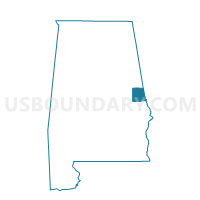
Fredonia Voting District, Chambers County, Alabama
About
Outline

Summary
| Unique Area Identifier | 521319 |
| Name | Fredonia Voting District |
| County | Chambers County |
| State | Alabama |
| Area (square miles) | 37.41 |
| Land Area (square miles) | 35.49 |
| Water Area (square miles) | 1.92 |
| % of Land Area | 94.86 |
| % of Water Area | 5.14 |
| Latitude of the Internal Point | 32.96927510 |
| Longtitude of the Internal Point | -85.26718870 |
Maps


Graphs
Select a template below for downloading or customizing gragh for Fredonia Voting District, Chambers County, Alabama


Neighbors
Neighoring Voting District (by Name) Neighboring Voting District on the Map
- 28505 - WEST POINT Voting District, Troup County, GA
- 28507 - EAST VERNON Voting District, Troup County, GA
- 28511 - LONG CANE Voting District, Troup County, GA
- Buffalo-Lebanon /Five Points /Penton Voting District, Chambers County, AL
- LaFayette, Chambers County, AL
- Lakeview/Lanett/Huguley Rescue Voting District, Chambers County, AL
- Stroud/Standing Rock Voting District, Chambers County, AL
Top 10 Neighboring County Subdivision (by Population) Neighboring County Subdivision on the Map
- LaGrange CCD, Troup County, GA (47,489)
- Lanett CCD, Chambers County, AL (9,961)
- West Point CCD, Troup County, GA (5,503)
- La Fayette CCD, Chambers County, AL (5,427)
- Five Points CCD, Chambers County, AL (2,537)
Top 10 Neighboring Place (by Population) Neighboring Place on the Map
Top 10 Neighboring Unified School District (by Population) Neighboring Unified School District on the Map
Top 10 Neighboring State Legislative District Lower Chamber (by Population) Neighboring State Legislative District Lower Chamber on the Map
- State House District 129, GA (53,120)
- State House District 69, GA (51,692)
- State House District 37, AL (43,958)
Top 10 Neighboring State Legislative District Upper Chamber (by Population) Neighboring State Legislative District Upper Chamber on the Map
- State Senate District 28, GA (191,899)
- State Senate District 29, GA (173,136)
- State Senate District 13, AL (132,777)
Top 10 Neighboring 111th Congressional District (by Population) Neighboring 111th Congressional District on the Map
Top 10 Neighboring Census Tract (by Population) Neighboring Census Tract on the Map
- Census Tract 9609.02, Troup County, GA (6,815)
- Census Tract 9540, Chambers County, AL (6,669)
- Census Tract 9610, Troup County, GA (5,503)
- Census Tract 9538, Chambers County, AL (3,619)
- Census Tract 9539, Chambers County, AL (2,900)